
A new federal test would decide which creeks count
Most people never wonder whether the creek at the end of their street is "federal." But that label matters. If a stream or wetland falls under the Clean Water Act as one of the "waters of the United States," or WOTUS, filling it in, piping it, or discharging into it usually needs a federal permit. If it doesn't, only state and local rules apply, and those differ a lot from one state to the next.
Where that line sits has been argued over for decades. In 2023 the Supreme Court narrowed it in Sackett v. EPA [3], and the U.S. Environmental Protection Agency (EPA) and the U.S. Army Corps of Engineers have been rewriting the definition ever since. They published a proposal in November 2025 [2]. Then, on September 9, 2026, they put out a supplement with a much stricter option [1]. Public comments closed on October 9, 2026. No date has been set for a final rule, and nothing has changed on the ground yet.
Under the WOTUS perennial test, a creek needs water almost every day
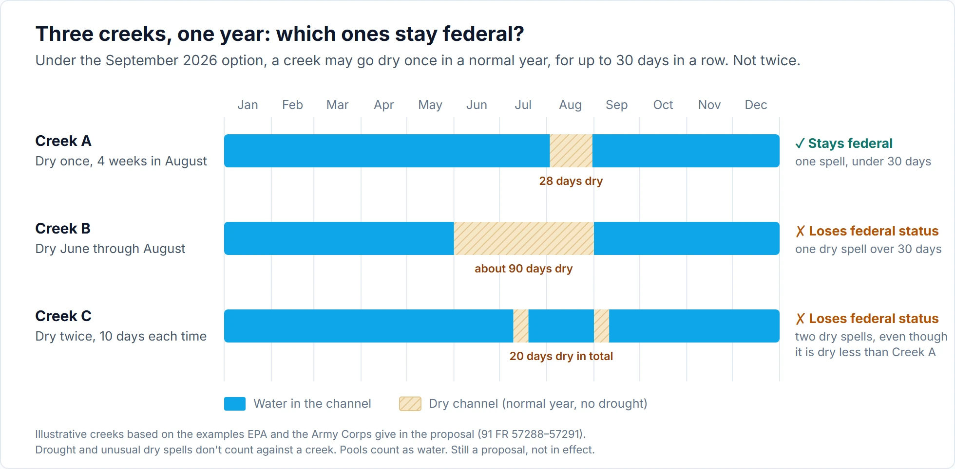
Under the new option, a stream counts only if it's perennial, meaning it has water in it every day of the year in a normal year [1]. The water doesn't have to be moving: standing pools count. There's one allowance: in a normal year it can go dry once, for up to 30 days in a row. Not longer than that, and not twice. Drying caused by a drought or an unusually dry spell doesn't count against it [1].
The agencies' own examples show how strict that is. A creek that dries up for four weeks every August still counts. A creek that dries up every summer from June through August doesn't. And a creek that dries up twice every year, for ten days each time, doesn't count either, even though it's dry for fewer days in total than the first one [1].
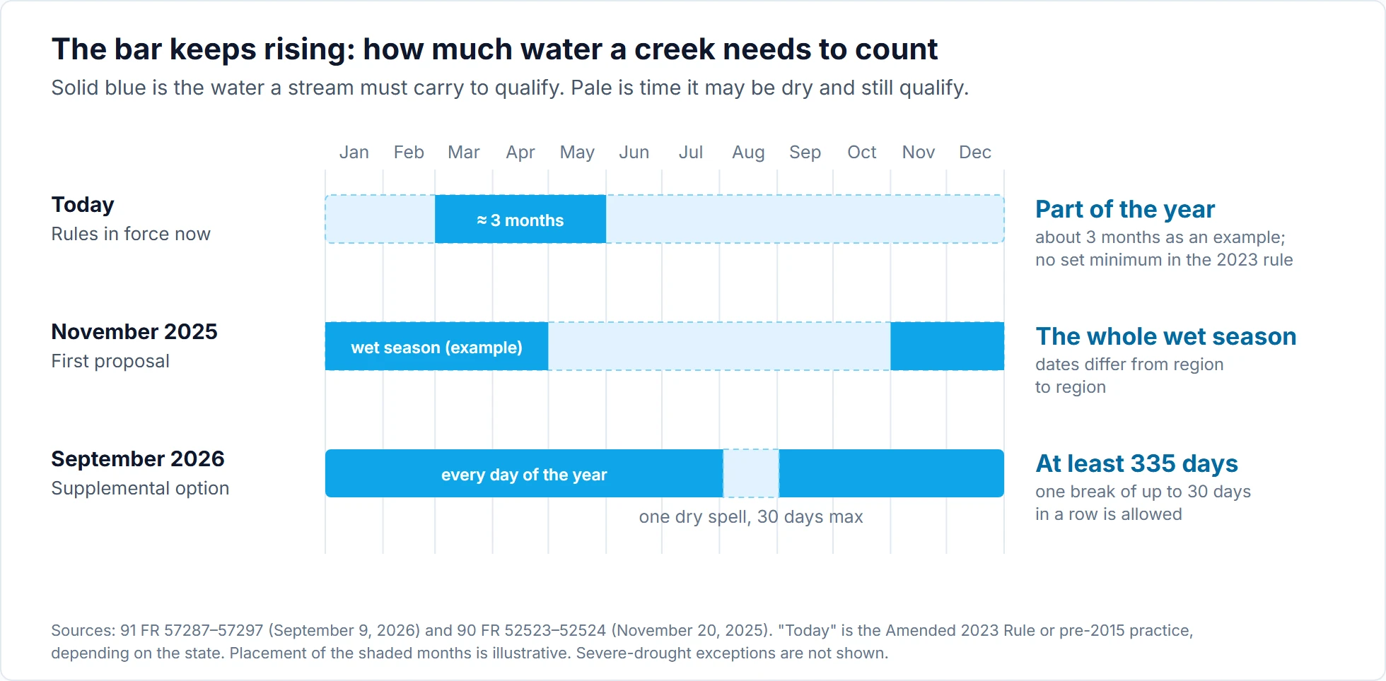
That's a big step from the rules in place today, which differ by state. Because of court injunctions, roughly half the states follow the Amended 2023 Rule and the rest follow the pre-2015 approach [2]. Neither sets a fixed minimum: the pre-2015 guidance gives about three months of flow as an example, and the Amended 2023 Rule sets no minimum at all [1]. The November 2025 proposal raised the bar to the whole wet season [2]. The new option raises it again, to at least 335 days of water a year.
Millions of miles of streams and many wetlands would fall outside
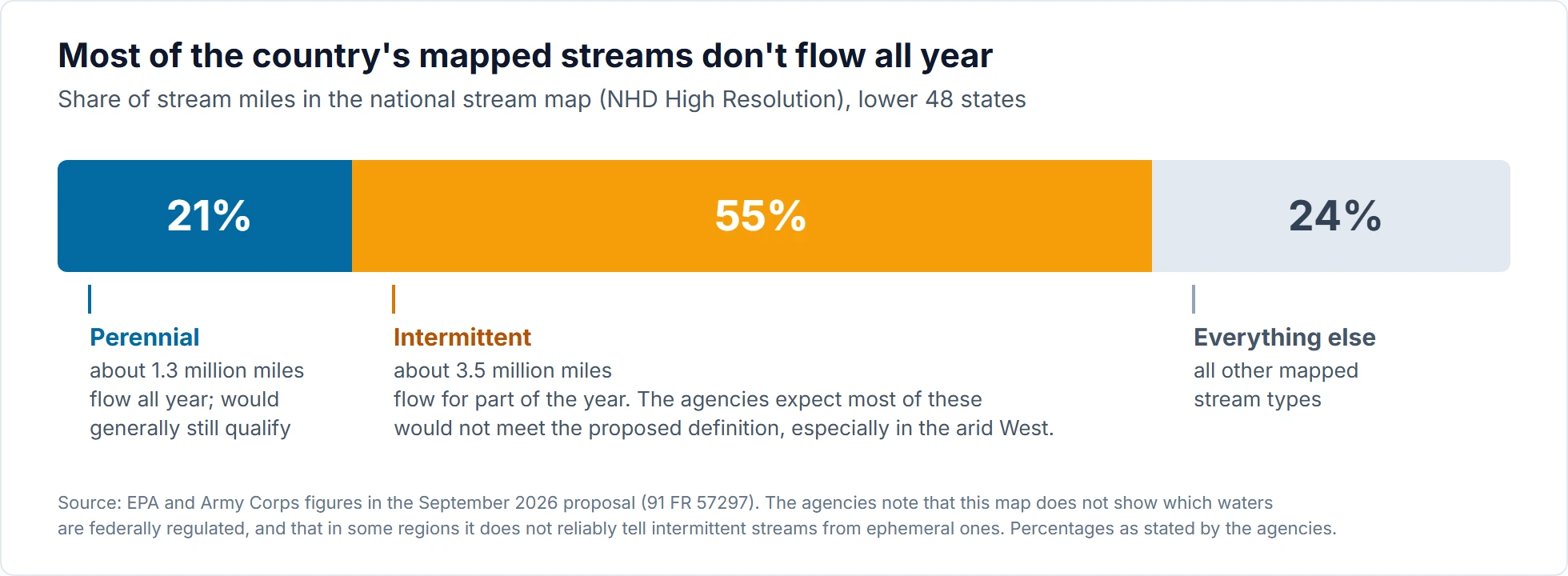
Most streams in this country don't flow all year. On the national stream map for the contiguous U.S., about 1.3 million miles of streams are labeled perennial and about 3.5 million miles intermittent, meaning they flow only part of the year [1]. The agencies say they expect most intermittent streams wouldn't meet the new definition, and that the arid West would feel it most [1].
Wetlands get the same treatment. A wetland would count only if it holds surface water all year, with the same allowances, and blends into a protected stream or lake so closely that you can't easily tell where one ends and the other begins. Only that blended part would be covered [1]. Most wetlands don't hold standing water year-round, and the agencies expect that most wetlands protected today as "adjacent" wetlands would no longer qualify [1].
What it means if you don't work in water
For farmers, builders, and landowners, a narrower and clearer line means fewer federal permits, less cost, and less waiting. The agencies say a perennial test is one landowners can understand without hiring a consultant to interpret it [1]. For people downstream, it means many small streams and wetlands would have only whatever protection their state chooses to give them. Those streams still carry water, sediment, and anything dumped in them into bigger rivers when they do flow.
The whole test hinges on counting dry days, and almost nobody has counted them. The agencies say it won't take continuous monitoring, and that people could often tell just by looking [1]. Some commenters warned it would take repeat visits or daily records [1], and we agree with them. Very few small creeks have a stream gauge, and a site visit shows you one day, not a year. So once a rule like this takes effect, deciding which side of the line a particular creek falls on will turn into an argument about data. The rest of this post is about that argument.
The rule counts dry spells, not just dry days
The proposed text lets a perennial water go dry for "a single period of up to 30 consecutive days in any given year" because of ordinary events like low tide or a regular dry spell [1]. The 30 days can straddle two calendar months, and the "year" doesn't have to be a calendar year; the agencies give September to August as an example. A second ordinary dry period in the same year, of any length, makes the stream intermittent in the agencies' reading. Their example is two 10-day dry spells, which fail even though they add up to only 20 days [1].
Three qualifiers in the text matter for anyone counting. First, "dry" means no standing or flowing water, so a day of zero flow with pools left in the channel is not a dry day. Second, only "non-anomalous" interruptions count: a regular, predictable dry period that happens around the same time every year. Drought and unusual dry spells are excused [1]. Third, the test describes the stream "during ordinary conditions," so one odd year with two dry spells doesn't settle the question. What matters is the stream's normal pattern.
So this isn't a simple duration threshold. It's a duration threshold plus a count of dry spells. That has odd consequences. A stream that's dry for 30 straight days passes. A stream that dries for 20 days, gets a two-day pulse from a summer storm, then dries for another 12 days looks like it fails, despite having less dry time and more flow. The text doesn't say whether a short storm pulse splits one dry spell into two. We expect that to be one of the first questions raised in implementation.
The agencies also asked whether 30 days is the right number [1], so the threshold may move in the final rule. The structure is what matters for practitioners: in a normal year, how many separate periods the channel holds no standing or flowing water, and how long the longest one lasts. That's a different kind of evidence from anything a jurisdictional determination needs today.
The drought exception rests on a rainfall map
Drying caused by an anomalous event doesn't count against a perennial stream, and there's no limit on how long that dry period lasts [1]. The proposed rule text names two such events: drought and an unusual dry spell. The agencies are considering a narrow reading of drought, set out in the preamble rather than the rule text: only extreme (D3) and exceptional (D4) drought on the U.S. Drought Monitor would qualify, and only for five years. After that, the drought becomes the new normal, and a stream that hasn't started flowing again drops out [1]. The five years mirror how long an approved jurisdictional determination stays valid under existing Corps guidance [1].
The agencies describe the Drought Monitor as a precipitation-driven tool, relying on precipitation indices over periods of 1 to 72 months [1]. The weekly map itself blends rainfall with soil moisture, streamflow, and other indicators, plus input from local experts [7]. Either way, it tells you a region was in drought. It doesn't tell you whether a particular reach dried up because of that drought or would have dried anyway. The other tools the agencies mention, the Corps' Antecedent Precipitation Tool and the climate-division Palmer Drought Severity Index, are also regional rainfall and water-balance indicators [1]. Connecting a dry channel to a D3 week will take a reach-scale argument those tools can't make by themselves.
"Ordinary conditions" is also a moving target. Zipper and colleagues looked at 540 USGS gauges on non-perennial streams from 1980 to 2017. Half showed a significant trend in at least one measure of intermittency, and 41 percent showed a trend in how long the streams stayed dry. Streams in the south were generally drying and streams in the north getting wetter [5]. Under a rule that resets "normal" after five years of drought, some streams will change status as the climate record shifts. A determination that holds up in 2027 may rest on a different baseline by 2032.
Today's tools answer a slightly different question
Practitioners already have ways to judge how long a stream flows. None of them was designed to answer the question this rule asks: in a normal year, was the longest dry spell 30 days or less, and was it the only one?
| Tool | What it tells you | Why it falls short of the proposed test |
|---|---|---|
| National Hydrography Dataset (NHD) | Where streams are, with a mapped perennial or intermittent label | The agencies say it can't represent the new definitions, and in some regions it doesn't separate intermittent from ephemeral streams [1] |
| Streamflow Duration Assessment Methods (SDAMs) | Ephemeral, intermittent, or perennial class from a single field visit | Its "perennial" class allows no dry days at all. In the arid West and Western Mountains it separates perennial from non-perennial streams correctly 83–84% of the time [4] |
| PROSPER (USGS) | The yearly chance that a channel flows all year, on a 30 m grid for the Pacific Northwest | Answers "year-round or not," not how long or how often a stream dries; regional coverage only [6] |
| Antecedent Precipitation Tool and Drought Monitor | Whether a site visit or a dry period fell in normal, wet, or drought conditions | Measures regional dryness, not water in a specific channel [1] |
| USGS stream gauges | Daily flow, so zero-flow spells can be counted directly | Zero flow isn't the same as dry, because pools can remain. Rare on the small streams this rule is mostly about |
The SDAM row deserves a closer look, because SDAMs are what most field staff will reach for first. The final methods for the arid West and Western Mountains were developed on 387 stream reaches and released in 2024 [4]. On test sites held back from calibration, they got all three classes right 64 to 69 percent of the time. Their most common mistake was confusing intermittent and perennial streams [4]. Under the new option, that's exactly where the legal line falls.
The definitions don't quite line up either. The SDAM manual defines a perennial reach as one that flows continuously through a year of normal rainfall [4], with no 30-day allowance. A stream that dries for three weeks every August would be intermittent to an SDAM, but could be perennial under the proposed rule. The manual also asks for flowing water, while the rule counts standing water too, so a reach that stops flowing but keeps its pools could fall on different sides of the two lines. An SDAM result of "intermittent" no longer means "non-jurisdictional."
A dry reach downstream can decide the whole project
The November 2025 proposal says that a downstream reach without relatively permanent flow cuts off federal jurisdiction for the tributaries upstream of it [2]. Culverts, ditches, and other features that do carry relatively permanent flow don't cut it off, and neither does a water transfer in current operation [2]. The September supplement doesn't change that part [1]. The agencies admitted it means knowing whether such a reach exists anywhere between the project and a navigable river [2]. They also asked for comment on adopting the approach of the 2020 Navigable Waters Protection Rule instead, under which a tributary keeps its status through such breaks, so this piece could change in the final rule [2].
Put that together with a perennial test, and a single weak link matters a lot. A losing reach where the stream sinks into gravel, a channel crossing an alluvial fan, a stretch below a diversion: if any of them ordinarily goes dry for six weeks, every tributary above it, and the wetlands that depend on those tributaries, could lose federal status, including creeks that flow all year.
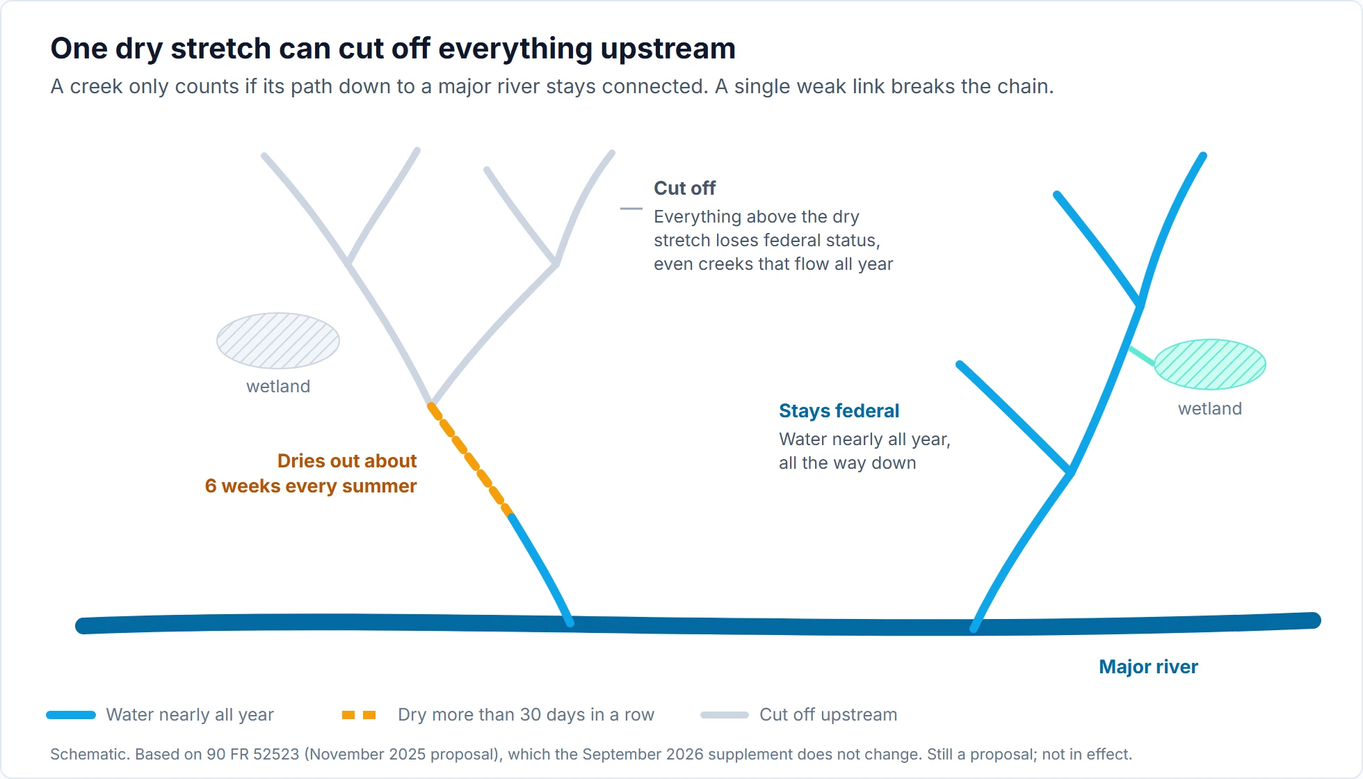
For anyone scoping a determination, this means looking downstream of the project, sometimes for miles, at reaches the client doesn't own and nobody has visited. Checking one reach is a field job. Finding the weakest reach on the whole flow path is a modeling job.
Start building the flow record now
If a perennial standard is finalized, we think jurisdictional work on anything but obvious cases will shift from a one-visit classification to a measured record of when a stream is wet and dry. Here's how we'd rank the evidence.
- Daily gauge records. If there's a USGS gauge on or near the reach, pull the daily values and work out, year by year, the longest stretch of zero flow and how many separate zero-flow stretches there were. Then note the Drought Monitor category for each dry year, and set aside the drought years to see the stream's normal pattern. That gets close to the rule's question in an afternoon. Zero flow at a gauge is an upper bound on dry days, though: if pools stay in the channel, those days aren't dry under the proposed definition, and photos or a logger can settle it. Our guide to USGS water data covers how to get the data. The catch is that small streams rarely have gauges.
- Water presence loggers. Cheap sensors that record whether water is in the channel, like the STIC loggers pictured in the SDAM manual [4], give a site-specific count of dry spells after one dry season. One season of logger data beats any number of single visits. Projects expecting a permit decision in 2027 or 2028 should get loggers in before summer 2027.
- Modeled daily flow, checked against dry spells. For ungauged reaches and for screening a downstream network, a calibrated watershed model or a regional data-driven model can produce daily flow and, from it, the odds that the longest zero-flow spell tops 30 days. Models don't simulate pools, so that's a conservative screen, not a direct answer. Most models are tuned to get flow volumes right, though, not the timing of zero flow. Before a model is used as evidence, it should be tested against observed dry spells, and it should report its uncertainty in days. Our diagnostic-guided calibration approach was built to look at low-flow behavior rather than average it away.
- SDAMs, NHD, PROSPER, and the APT for screening. Use them to sort streams into clearly ephemeral, clearly perennial, and close calls. Spend the effort from steps 1 to 3 on the close calls.
The mistakes we expect to see first follow from everything above: treating an SDAM "intermittent" result as the end of the analysis, reading an NHD label as an answer, treating every zero-flow day as a dry day, judging a stream on one unusual year, checking only the project reach, claiming a drought exception without documenting the Drought Monitor category for those weeks, and offering a model's overall fit statistics as proof that it gets dry spells right.
The perennial option is still a proposal, and debate is widely expected whichever definition is finalized. Until then the current rules apply, and they still differ by state. But the direction is clear enough to plan around. For any project expecting a jurisdictional determination in 2027 or 2028, we'd ask three questions now:
- Could any reach in the project area, or downstream of it, be within a few weeks of the 30-day line?
- If so, is there a daily record for it? If not, can loggers go in before the next dry season?
- Where no record can be collected in time, has the model been checked on dry spells? If not, it shouldn't carry the decision.
Teams that start collecting this record now will be ready whatever threshold ends up in the final rule. Teams that wait will be starting a season of fieldwork on the day the rule takes effect. LYNXCE helps with this through our water resources modeling services.
References
- U.S. Environmental Protection Agency and Department of the Army (2026). "Updated Definition of 'Waters of the United States'." Supplemental notice of proposed rulemaking. Federal Register 91(173): 57284-57301, September 9, 2026. Docket EPA-HQ-OW-2025-0322.
- U.S. Environmental Protection Agency and Department of the Army (2025). "Updated Definition of 'Waters of the United States'." Proposed rule. Federal Register 90: 52498, November 20, 2025. Docket EPA-HQ-OW-2025-0322.
- Sackett v. Environmental Protection Agency, 598 U.S. 651 (2023).
- Mazor, R., James, A., Fritz, K.M., Topping, B., Nadeau, T.-L., Fertik Edgerton, R., and Nicholas, K. (2024). Streamflow Duration Assessment Methods for the Arid West and Western Mountains of the United States. Version 2.0. Document No. EPA-843-B-24002. U.S. EPA and U.S. Army Corps of Engineers.
- Zipper, S.C., Hammond, J.C., Shanafield, M., et al. (2021). "Pervasive changes in stream intermittency across the United States." Environmental Research Letters 16(8): 084033. DOI: 10.1088/1748-9326/ac14ec.
- Jaeger, K.L., Sando, R., McShane, R.R., et al. (2019). "Probability of Streamflow Permanence Model (PROSPER): A spatially continuous model of annual streamflow permanence throughout the Pacific Northwest." Journal of Hydrology X 2: 100005. DOI: 10.1016/j.hydroa.2018.100005.
- National Drought Mitigation Center. "What is the USDM." U.S. Drought Monitor, University of Nebraska-Lincoln (accessed October 11, 2026).
Need help with your project?
LYNXCE's engineers and scientists apply this expertise directly to client projects. Free initial consultation.